
Section 1.1
Introduction
General introduction to the approach used in this project, including objectives and the McMurray Métis Cumulative Environmental and Cultural Effects Model for Community-Based Monitoring.
Introduction
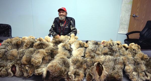
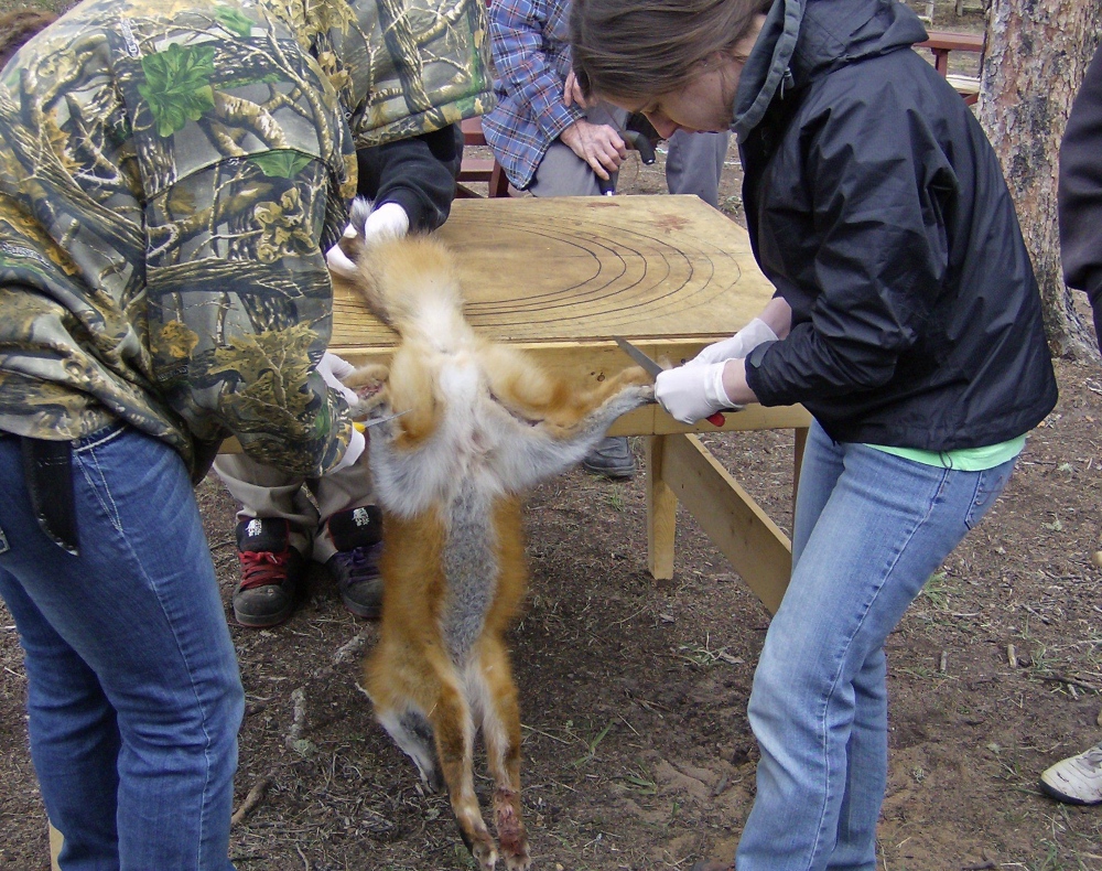
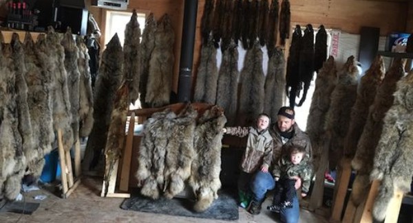
McMurray Métis members have worked traplines in the Fort McMurray area for generations. Trapping remains an important practice integral to the unique culture and community of McMurray Métis. For many community members, trapping and subsistence harvesting are maintained alongside employment and business activities in the large-scale commercial sector and for others trapping is a way of life. Traplines provide more than commercial benefits to trappers and their families. The traplines are Métis spaces where community members connect to cultural identity, youth are socialized and receive transmission of intergenerational knowledge, and family and community bonds are reproduced. However, with increasing industrial activity there is concern that traditional resources supporting trapping activities are being negatively affected.
Through this project, the McMurray Métis community, in collaboration with InnoTech Alberta and the Alberta Biodiversity Monitoring Institute, implemented a wildlife camera monitoring program to answer the question: Is industrial development near and on McMurray Métis traplines affecting the presence and densities of species on the traplines?
In addition to collecting valuable data on traditionally hunted and trapped species, this project provided opportunity for community members to design and conduct monitoring activities, to use the camera image data management system WildTrax, and to share their Indigenous knowledge with younger members of the community who helped with camera deployment, SD card collection, camera maintenance and photo tagging. Community members and staff from ABMI and InnoTech Alberta worked together to create and implement the camera monitoring project to meet the needs of the trappers and community staff related to understanding impacts of industrial development and natural disturbances such as wildfire, on the animals important to trapping and hunting.
Spotlight
For the Métis, Métis trappers especially, there's not too many of us in there. And that's just, it gives us something else to do and to look at the land with us. Like back on my line. I guess it just gives us an idea of what's happening in the bush. Helps us, because I mean, most of the Métis long ago were bush people. A lot of them, along the river. So all it does is, I shouldn't say all it does. It really helps in getting a lot of them back to the land again, even if they don't get on the land, but hey, there's some pictures taken from the land. And it's reminding them again of what was on the land, what they used to see. Some of them, that's the only way they're going to see it again, like the elders that can't get out there. There's the pictures there. Nice to look at. Maybe another few years, I can't get out there, I'll be sitting there enjoying them pictures. "I know that place!
Frank Lacaille
Community Based Monitoring
McMurray Métis Cumulative Environmental and Cultural Effects Model for Community-Based Monitoring
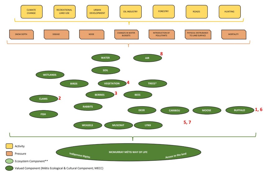
The wildlife camera monitoring project is part of the McMurray Métis’ broader Community-Based Monitoring Program, in which community members identified Métis Environmental and Cultural Components important to the community. Examples of these components include water, air, access to the land, and wildlife, including animals such as moose, buffalo, muskrat, and weasels. For the camera project, the monitoring project was designed to collect data on mammals and small furbearers important to hunting and trapping and McMurray Métis Way of Life.
The Cumulative Environmental and Cultural Effects Model provides a framework to define pathways of effects on valued components. The community members identified activities and potential pressures that generate impacts on Métis Environmental and Cultural Components to create the conceptual model. Activities such as different types of land use (i.e., forestry, oil sands development, urbanization) create pressures such as pollutants, land disturbance, or disease that potentially generate pathways of effects on valued components. More work through community-based monitoring is required to understand the pathways of effects on the Métis Environmental and Cultural Components. For this project, the camera monitoring program was designed to study how land disturbance and natural disturbance affect mammals and small furbearers.
The Cumulative Environmental and Cultural Effects Model also provides a framework to evaluate where gaps in information are in understanding the pathways of effects on Métis Environmental and Cultural Components. When gaps are identified, a community-based monitoring program can be designed to answer questions about pathways of effects on the components. As a recommendation from the community members, this approach is informed by both Métis Indigenous Knowledge and western scientific knowledge. Where western scientists are conducting monitoring that may provide information about the pathways of effects on Métis Environmental and Cultural Components, McMurray Métis seeks to collaborate and understand what information is being collected and how it informs the model. For example, in 2021-2022, McMurray Métis community members will work with Principal Investigators from the Oil Sands Monitoring Program studying mammals to identify how data from their monitoring programs may inform the pathways of effects for valued components identified by McMurray Métis. This work generated a series of sub-models for different animals. More work is needed to further develop the pathways of effects for each of the valued components.
The current design of the camera monitoring program was created through a collaboration between McMurray Métis trappers and western scientists at the Alberta Biodiversity Monitoring Institute (ABMI) and InnoTech Alberta. The camera locations were determined based on how trappers use the traplines; ABMI and InnoTech Alberta provided global positioning system (GPS) coordinates along the trails to create a sampling design that allowed for statistical analysis of the camera images, and accounted for the distance between cameras. The analysis applied to the camera images assessed different types of pressures such as distance of land disturbance (or human footprint) to the camera location, type of disturbance (or human footprint) on the trapline, and wildfire history of the trapline. This approach generated data to understand how much and what type of disturbance is present on each trapline and whether the amount and type of disturbance (anthropogenic or natural) had any relationship to the animals captured on the cameras.
The goal of the Cumulative Environmental and Cultural Effects Model is to generate a common understanding of how cultural and environmental systems function in McMurray Métis Traditional Territory. The model is designed to identify cause-effect relationships and understand how causal pathways through the human-ecological system can affect the McMurray Métis way of life, both presently and into the future. Identifying and understanding activities, pressures, and components is essential to this model. The camera monitoring project provides data to test hypotheses about the type and amount of land disturbance and the pathways of effects of these disturbances on mammals and small furbearers. It is the goal of McMurray Métis to have community members lead and develop this knowledge system at all stages and to expand community-based monitoring to collect data to validate the cause-effect relationships that have potential to impact McMurray Métis Way of Life.
Cumulative Effects
Cumulative Effects Assessment Approach
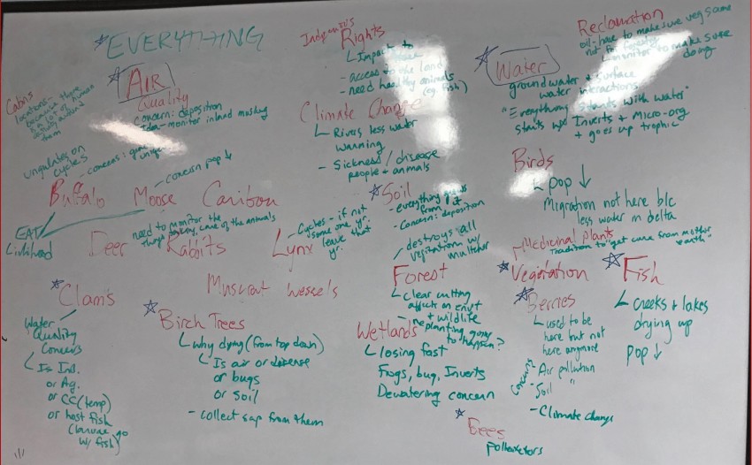
An understanding of cumulative effects is central to all McMurray Métis monitoring activities. The cumulative effects assessment approach acknowledges the holistic nature of the system, and recognizes the inter-connectedness of everything, including air, water, land, rights, animals, plants, soil, wetlands, and reclamation. The cumulative effects assessment approach is used by McMurray Métis to describe how human and environmental components interact throughout McMurray Métis’ Traditional Territory.
This approach is not specific to any one project, program, field of study, or time-period. Most environmental impact assessments and regulatory processes in the Oil Sands Region focus on one project at a time, but the reality is all projects are in construction and operations simultaneously throughout the territory generating cumulative impacts. McMurray Métis uses the cumulative effects assessment methodology to describe the past, present and future conditions of the Traditional Territory and the traplines studied in this camera monitoring project. In this way, multiple impacts on Métis Environmental and Cultural Components can be assessed additively to provide a territory-wide understanding of current conditions compared to past conditions or historic baseline described by Métis Elders and knowledge holders. It is important that the historic baseline for impact assessment acknowledges the long history of Métis people in northeastern Alberta, which dates back to before colonial control.
Whenever you’re in a consultation meeting or something like that, they [oil industry representatives] always talk about how small the footprint is, so to speak, but I’ve always often wondered if you actually put them all together collectively... that’s kind of a sasquatch footprint I’d have to say. But there’s a reason why they keep it separate... if they did it as a collective they wouldn’t get to have the projects approved I wouldn’t think.
Sheryl Huppie